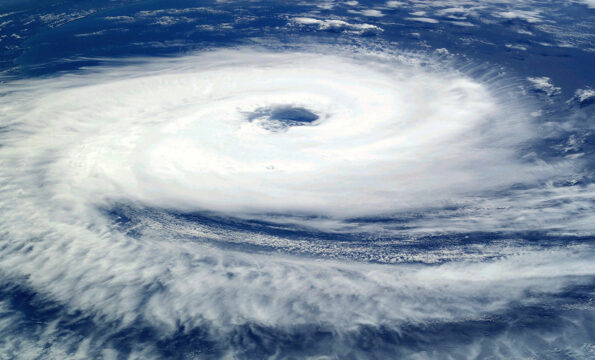
The Washington Post, by Dan Stillman: California and the Desert Southwest could see exceptional amounts of rain in the next week as Hurricane Hilary, which developed Thursday morning off the coast of Mexico and was rapidly intensifying, threatens to deluge the region with an unusually strong atmospheric river. Along the coast, high surf and large swells are possible, while potential wind impacts are uncertain.
Hilary is expected to further strengthen Thursday into Friday, the National Hurricane Center said, as it gains strength from extremely warm waters in the eastern Pacific Ocean. While Hilary is likely to weaken as it tracks northward over colder waters, it could make landfall on Baja California or Southern California on Sunday or Monday as a tropical storm, bringing several inches of rain — and possibly flooding — to areas in the midst of drought.
“Confidence continues to increase on a significant heavy rainfall/high impact event to unfold and focus across parts of the Southwest and California beginning Saturday to at least Monday,” the National Weather Service said Thursday. ”
Hilary has the potential to be the first tropical storm to make landfall in California since 1939. It’s unusual, but not unprecedented, for tropical systems to impact California. Last year, Tropical Storm Kay brought wind gusts of more than 100 mph and flooding to Southern California despite not making landfall on the state.
Hurricane Hilary develops and is rapidly intensifying
Hurricane Hilary, a Category 1 storm with maximum sustained winds of 75 mph, was located about 320 miles south of Manzanillo, Mexico, early Thursday, and could strengthen to a Category 4 storm with winds of 130 mph as it follows a track to the northwest and then north during the next several days, generally parallel to the southwest Mexico coast and over extremely warm ocean waters.
“The environment is ripe for Hilary to rapidly intensify during the next couple of days,” the Hurricane Center said, noting sea surface temperatures near 86 degrees and low wind shear, or the lack of increasing winds with altitude that can prevent storms from strengthening.
The warm waters off the coast of Mexico are associated with one of several ongoing marine heat waves across the world’s oceans. Hilary is likely to weaken below hurricane strength as it encounters much colder waters by the weekend. However, because Hilary is being accelerated northward by an unusual weather pattern, it could still be a tropical storm as far north as Southern California.
Confidence has grown in Hilary’s track forecast, leading to increased confidence in heavy rainfall. But its “angle of approach to the west coast of the Baja California peninsula does make it nearly impossible to know at this point if the center will remain just offshore or move over the peninsula before reaching the southwestern United States,” the Hurricane Center said, which makes it hard to predict the wind impacts with confidence.
“Although it is too soon to determine the location and magnitude of wind impacts, interests in these areas should monitor the progress of Hilary and updates to the forecast,” the Hurricane Center said. “Heavy rainfall associated with Hilary may produce areas of flash flooding and result in landslides over portions of the Baja California peninsula from late Friday into late Sunday. Rainfall impacts from Hilary within the Southwestern United States are expected to peak on Sunday and Monday. Large swells from Hilary will spread northward along the coast of southwestern Mexico and the Baja California Peninsula during the next several days.”
Atmospheric River likely to bring 2-7 inches of rain across Southwest
Hilary, or its remnants, is likely to unleash an atmospheric river on portions of Southern California and the Desert Southwest this weekend into early next week. Atmospheric rivers are essentially a fire hose of tropical moisture that produce extreme amounts of rainfall in short periods of time. This one could peak at a level 4 or 5, the highest levels of the atmospheric river scale, Sunday into Monday.
The atmospheric river could fuel extreme amounts of perceptible water, a measure of atmospheric moisture, which is forecast to be greater than two inches. The predicted surge of moisture could be at a level “almost never experienced this time of year,” the National Weather Service in Phoenix said.
The Weather Service is predicting at least four to seven inches of rain for parts of Southern California and southern Nevada, and two to four inches in western Arizona through early next week. While portions of the region are in the midst of a moderate drought according to the latest federal drought monitor, too much rain too fast could lead to flooding over a region prone to excessive runoff because of dry soils.
Coastal marine hazards are a concern, in addition to the potential for heavy rain. The National Weather Service in Los Angeles is warning of “the potential for hazardous marine conditions to all coastal waters starting this weekend. While any wind/weather impacts from these systems over the local area are highly uncertain, long-period, steep, southerly swells and high surf will be possible during the upcoming weekend and beyond.”
California tropical history and elsewhere in the Pacific
While relatively rare, tropical storms have impacted California before. Just last September, Tropical Storm Kay brought wind gusts up to 109 mph to the high terrain of Southern California and more than three inches of rain. The storm took down trees and power lines, flooded roads and triggered rockslides.
The only known hurricane to make landfall in California was a Category 1 storm that came ashore near San Diego on Oct. 2, 1858, bringing 39 to 73 mph winds to coastal areas as far north as Long Beach and flooding to inland areas. Somewhat more recently, on Sept. 25, 1939, a tropical storm made landfall between San Diego and Long Beach, producing 50 mph winds and flooding that killed at least 45 people.
The hurricane season continues to be a busy one in the eastern Pacific. The remnants of what is Tropical Storm Fernanda could bring showers to Hawaii early next week. Meanwhile, Tropical Storm Greg is passing south of Hawaii today in the central Pacific, not far from where Hurricane Dora moved through last week.
Prophetic Link:
“The restraining Spirit of God is even now being withdrawn from the world. Hurricanes, storms, tempests, fire and flood, disasters by sea and land, follow each other in quick succession. Science seeks to explain all these. The signs thickening around us, telling of the near approach of the Son of God, are attributed to any other than the true cause. Men cannot discern the sentinel angels restraining the four winds that they shall not blow until the servants of God are sealed; but when God shall bid His angels loose the winds, there will be such a scene of strife as no pen can picture.” Testimonies to the Church, Vol 6, page 408.1.
Comments